Today Cloudy | Tonight Snow Showers Early |
| 26°F | 15°F |
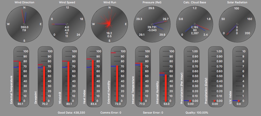
Highest temperature today = 25.6°F at 12:43 PM
Lowest temperature today= 14.6 °F at 7:18 AM
Average temperature today= 20.8 °F
Highest dewpoint today = 15.3 °F at 12:00 AM
Lowest dewpoint today = 8.5 °F at 7:14 AM
Average dewpoint today = 11.9 °F
Average external humidity today = 68 %
Highest wind chill today = 23.9 °F at 12:34 PM
Lowest wind chill today = 12.8 °F at 5:18 AM
Highest heat index today= 25.6 °F at 12:43 PM
Average heat index today = 20.8 °F
Lowest pressure today = 30.10 inHg at 3:02 PM
Highest wind gust today = 14 MPH at 11:16 AM
Average Wind Speed Today = 3.0 MPH
Highest rain rate today= 0.04 in/h at 1:00 PM
Rain today = 0.08 in
6 MPH
Highest temperature yesterday = 27.7°F at 4:17 PM
Lowest temperature yesterday= 13.0 °F at 7:43 AM
Average temperature yesterday= 21.4 °F
Highest dewpoint yesterday = 21.3 °F at 2:51 PM
Lowest dewpoint yesterday = 10.0 °F at 7:31 AM
Average dewpoint yesterday = 15.5 °F
Average external humidity yesterday = 78 %
Highest wind chill yesterday = 25.4 °F at 6:15 PM
Lowest wind chill yesterday = 11.7 °F at 5:36 AM
Highest heat index yesterday= 27.7 °F at 4:17 PM
Average heat index yesterday = 21.4 °F
Lowest pressure yesterday = 30.02 inHg at 5:07 PM
Highest wind speed yesterday = 17 MPH at 2:44 PM
Average wind speed yesterday= 2.8 MPH
Highest rain rate yesterday= 0.00 in/h at 11:00 PM
Rain yesterday = 0.01 in
Highest temperature this week = 31.7°F on 25 Jan 2026 5:53 PM
Lowest temperature this week = 13.0 °F on 27 Jan 2026 7:43 AM
Average temperature this week = 22.7 °F
Number of frost days this week: 4
Highest dewpoint this week = 30.8 °F on 25 Jan 2026 6:53 PM
Lowest dewpoint this week = 8.5 °F on 28 Jan 2026 7:14 AM
Average dewpoint this week = 18.0 °F
Average external humidity this week = 82 %
Highest wind chill this week = 31.7 °F on 25 Jan 2026 5:53 PM
Lowest wind chill this week = 8.3 °F on 25 Jan 2026 6:53 AM
Highest heat index this week = 31.7 °F on 25 Jan 2026 5:53 PM
Average heat index this week = 22.7 °F
Lowest pressure this week = 29.53 inHg on 26 Jan 2026 12:53 PM
Highest wind speed this week = 22 MPH on 25 Jan 2026 8:23 AM
Average wind speed this week = 2.1 MPH
Highest rain rate this week = 0.34 in/h on 25 Jan 2026 5:23 PM
Rain this week = 0.70 in
Number of rain days this week: 2
Highest temperature last week = 55.4°F on 22 Jan 2026 3:53 PM
Lowest temperature last week = 12.3 °F on 24 Jan 2026 7:23 AM
Average temperature last week = 22.7 °F
Number of frost days last week: 7
Highest dewpoint last week = 38.0 °F on 18 Jan 2026 12:23 PM
Lowest dewpoint last week = -4.5 °F on 24 Jan 2026 7:53 AM
Average dewpoint last week = 21.1 °F
Average external humidity last week = 67 %
Highest wind chill this week = 54.5 °F on 22 Jan 2026 3:53 PM
Lowest wind chill last week = 2.7 °F on 24 Jan 2026 7:53 AM
Highest heat index last week = 55.4 °F on 22 Jan 2026 3:53 PM
Average heat index last week = 31.4 °F
Lowest pressure last week = 29.84 inHg on 18 Jan 2026 3:23 PM
Highest wind speed last week = 26 MPH on 24 Jan 2026 2:23 AM
Average wind speed last week = 2.7 MPH
Highest rain rate last week = 1.99 in/h on 19 Jan 2026 9:23 AM
Rain last week = 0.21 in
Number of rain days last week: 2
Highest temperature this month = 63.8°F on 7 Jan 2026 1:53 PM
Lowest temperature this month = 12.3 °F on 24 Jan 2026 7:23 AM
Average temperature this month = 34.8 °F
Number of frost days this month: 20
Highest dewpoint this month= 55.1 °F on 10 Jan 2026 8:23 PM
Lowest dewpoint this month= -4.5 °F on 28 Jan 2026 7:14 AM
Average dewpoint this month= 26.6 °F
Average external humidity this month = 73 %
Highest wind chill this month = 63.8 °F on 7 Jan 2026 1:53 PM
Lowest wind chill this month= 2.7 °F on 24 Jan 2026 7:53 AM
Highest heat index this month = 63.8 °F on 7 Jan 2026 1:53 PM
Average heat index this month = 34.8 °F
Lowest pressure this month = 29.42 inHg on 15 Jan 2026 1:53 AM
Highest wind speed this month= 35 MPH on 11 Jan 2026 8:53 PM
Average wind speed this month = 2.6 MPH
Highest rain rate this month = 1.99 in/h on 19 Jan 2026 9:23 AM
Rain this month = 2.90 in
Number of rain days this month: 5
| Today Cloudy | Tonight Snow Showers Early |
| 26°F | 15°F |

|

|
| Radar/Satellite images courtesy of NOAA/NWS and Noaa Star GOES Imagery. | |
January so far has been... Cooler than average (34.83°F versus an average of 37.05) Wetter than average (2.90 in versus an average total of 2.20) Calmer than average (a wind run of 1,696 miles versus an average of 1,814)
Last Update: 28 Jan 2026 3:23 PM
Current Temp: 23.5 °F (-0.9)
Current Heat Index: 23.5 °F (-0.9)
Current Wind Chill: 21.6°F (0.9)
Current Dew Point: 13.5°F (2.1)
Current Humidity: 65 % (8)
High Today: 25.6 °F at 12:43 PM
Low Today: 14.6 °F at 7:18 AM
Highest Heat Index Today: 25.6 °F at 12:43 PM
Lowest Wind Chill Today: 12.8 °F at 5:18 AM
Current Indoor Temperature 72.3
Click for our Weather Data at AWEKAS
Local Sunrise Time Today: 7:12 AM
Local Sunset Time Today: 5:22 PM
Daylight Time Today: 10:10
Local Sunrise Time Tomorrow: 7:11 AM
Local Sunset Time Tomorrow: 5:23 PM
Daylight Time Tomorrow: 10:11
Last Update: 28 Jan 2026 3:23 PM
Current Pressure: 30.10 inHg (-0.01)
Current Wind Direction: WSW
Average Wind Speed: 2 MPH (-1)
Highest Wind Gust Today: 14 MPH at 11:16 AM
Highest Wind Reading past 10 Minutes :7mph
The 10 Minute Average Wind Speed : 2.1mph
Current Rainrate: 0.00 in/h (0.00)
Today's Rain: 0.08 in
Rain Days This Month: 5
Current Indoor Humidity 20
Local and Regional Forecast Regional Forecast Discussion NHC Atlantic Storms Toddville Weather Historical Weather History Mid Atlantic River Forecast Center National Weather Service Wakefield, Va
| National Weather Service Forecast for:
3 Miles W Elliott, MD Issued by: National Weather Service Wakefield, VA |
||||||||||||||||||||||||||||||||||||||||
| Updated: 2:10 pm EST Jan 28, 2026 | ||||||||||||||||||||||||||||||||||||||||
| Toddville, MD (ERH) | ||||||||||||||||||||||||||||||||||||||||
|
||||||||||||||||||||||||||||||||||||||||
| This Afternoon |
Partly sunny, with a high near 25. Northwest wind around 7 mph. |
| Tonight |
A chance of snow between 7pm and 1am. Mostly cloudy, with a low around 14. Northwest wind 5 to 16 mph. Chance of precipitation is 30%. New snow accumulation of less than half an inch possible. |
| Thursday |
Sunny, with a high near 26. Wind chill values as low as -1. Northwest wind 14 to 17 mph. |
| Thursday Night |
Partly cloudy, with a low around 12. Wind chill values as low as 0. Northwest wind around 13 mph. |
| Friday |
Mostly sunny, with a high near 24. Northwest wind 7 to 10 mph. |
| Friday Night |
A chance of snow after 7pm. Mostly cloudy, with a low around 12. Chance of precipitation is 30%. |
| Saturday |
Snow likely. Mostly cloudy, with a high near 23. Chance of precipitation is 60%. New snow accumulation of 1 to 3 inches possible. |
| Saturday Night |
Snow likely. Cloudy, with a low around 16. Chance of precipitation is 70%. New snow accumulation of 1 to 2 inches possible. |
| Sunday |
Snow likely. Mostly cloudy, with a high near 28. Chance of precipitation is 70%. |
| Sunday Night |
A chance of snow before 7pm. Partly cloudy, with a low around 18. Chance of precipitation is 30%. |
| Monday |
Sunny, with a high near 33. |
| Monday Night |
Partly cloudy, with a low around 21. |
| Tuesday |
Mostly sunny, with a high near 35. |
| Tuesday Night |
Partly cloudy, with a low around 21. |
Forecast from NOAA-NWS for 3 Miles W Elliott, MD.
                                    MONTHLY CLIMATOLOGICAL SUMMARY FOR Jan 2026

NAME: TODDVILLE MARYLAND KMDTODDV2
ELEV: 10.0 Feet  LAT: 038° 18' 18" N  LONG: 076° 05' 02" W

                                    TEMPERATURE (°F)  RAIN (in)  WIND SPEED (MPH)

                                                  HEAT     COOL              AVG
       MEAN                                       DEG      DEG               WIND                      DOM
DAY    TEMP    HIGH   TIME      LOW    TIME       DAYS     DAYS     RAIN     SPEED    HIGH    TIME     DIR
-------------------------------------------------------------------------------------------------------------
01     32.3    40.1   04:49     23.7   20:01      32.7      0.0     0.00      4.0     23.0    08:39    NNW
02     29.5    38.2   14:23     24.6   23:53      35.5      0.0     0.00      1.2      8.0    12:23    E
03     28.2    34.1   13:53     21.4   06:53      36.8      0.0     0.00      0.7      8.0    14:53    W
04     31.5    40.4   15:53     26.0   20:23      33.5      0.0     0.00      1.2     14.0    13:23    SSE
05     34.3    43.7   20:23     22.5   06:53      30.7      0.0     0.00      1.5     12.0    22:53    S
06     43.4    49.8   17:53     34.5   06:23      21.6      0.0     0.00      1.3      8.0    20:53    SW
07     51.2    63.8   13:53     38.4   23:53      13.8      0.0     0.00      2.8     14.0    11:53    W
08     41.0    53.0   12:23     31.7   06:23      24.0      0.0     0.00      0.7      8.0    12:23    SW
09     47.0    57.0   13:23     35.4   08:23      18.0      0.0     0.00      1.8     15.0    12:23    SSE
10     51.1    55.4   20:23     47.0   23:23      13.9      0.0     1.93      2.1     22.0    20:23    ESE
11     43.6    48.8   00:23     35.0   23:53      21.4      0.0     0.03      4.5     35.0    20:53    NW
12     37.2    43.0   15:23     32.4   07:53      27.8      0.0     0.00      3.7     18.0    00:23    NW
13     40.0    48.4   14:23     28.5   06:53      25.0      0.0     0.00      2.0     13.0    13:53    SSW
14     44.8    47.9   11:53     41.8   07:53      20.2      0.0     0.03      2.7     13.0    21:53    SW
15     35.1    43.4   04:23     24.0   23:23      29.9      0.0     0.00      5.9     26.0    10:53    NW
16     30.8    39.2   23:53     24.0   00:23      34.2      0.0     0.00      5.2     27.0    02:23    NW
17     39.1    43.4   13:23     33.5   19:23      25.9      0.0     0.00      2.4     19.0    13:53    W
18     35.4    39.3   11:53     28.3   23:53      29.6      0.0     0.13      1.9     14.0    20:53    NNE
19     30.8    40.1   15:53     20.4   07:23      34.2      0.0     0.08      2.7     17.0    14:53    W
20     26.4    32.3   15:53     19.6   21:23      38.6      0.0     0.00      2.4     15.0    11:53    NW
21     31.1    40.8   15:53     17.7   01:53      33.9      0.0     0.00      2.3     19.0    15:23    SSW
22     43.1    55.4   15:53     30.7   22:53      21.9      0.0     0.00      2.8     16.0    11:53    W
23     35.4    49.5   15:53     25.5   06:23      29.6      0.0     0.00      2.0     22.0    23:23    NNE
24     17.8    24.7   00:23     12.3   07:23      47.2      0.0     0.00      4.7     26.0    02:23    NNE
25     24.4    31.7   17:53     15.9   02:23      40.6      0.0     0.61      2.7     22.0    08:23    NE
26     23.6    30.2   00:23     16.8   23:53      41.4      0.0     0.00      0.1      8.0    23:23    NW
27     21.5    27.7   16:17     13.0   07:43      43.5      0.0     0.01      2.8     17.0    14:44    WSW
28     20.8    25.6   12:43     14.6   07:18      29.5      0.0     0.08      3.0     14.0    11:16    NNE
-------------------------------------------------------------------------------------------------------------
       34.7    63.8     7       12.3    24       834.7      0.0     2.90      2.5     35.0     11      NW

Max >=  90.0:  0
Max <=  32.0:  5
Min <=  32.0:  20
Min <=   0.0:  0
Max Rain:   1.93 ON 01/10/26
Days of Rain: 8 (>.01 in) 3 (>.1 in) 1 (>1 in)
Heat Base:   65.0  Cool Base:   65.0
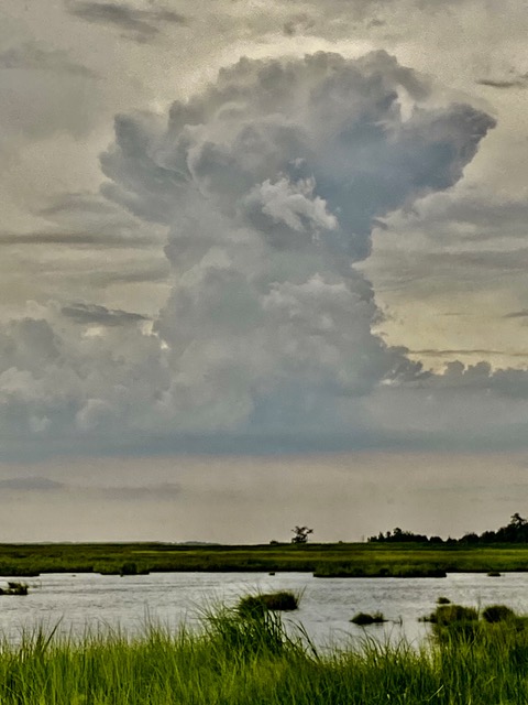
Current Conditions: Light Clouds
Current Forecast: Increasing clouds and warmer. Precipitation possible within 12 to 24 hours. Windy.
Current Short Forecast: Partly cloudy.
Random Weather Facts: On 14th April, 1986 Bangladesh was hit by the biggest hail stones ever recorded - weighing in at over 1kg (2.2lb) each - killing 92 people.
Internal Temperature 72.3
Internal Humidity 20
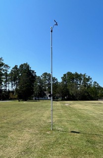
Our Weather Station Hardware
Davis Vantage Pro 2. Anemometer height 20"


NOAA Forecast Scripts Courtesy of Saratoga Weather and Carter Lake Weather
This weather station is privately owned and operated,. Never base any important decisions that could result in harm to people or property on this weather information.
Advisory Information Unavailable, error fetching or reading data from the NOAA advisories server.


